Punta Goloritzé
Punta Goloritzé
A limestone cliff classified as a natural monument, Punta Goloritzé can be explored on foot from the Golgo plateau or by boat from Santa Maria Navarrese. Its 143 m rocky needle and turquoise shingle beach make it an exceptional natural site on the east coast of Sardaigne.
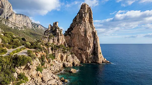
Punta Goloritzé is a limestone cliff that plunges into the Tyrrhenian Sea on the east coast of Sardaigne, in the municipality of Baunei. Classified as a natural monument since 1993, it is accessible only on foot or by sea. Its 143-meter rocky needle and the shingle beach at its base make it one of the most photographed natural sites on the island.
Practical Information at a Glance
- Access: on foot from the Golgo plateau (approximately 3 hours round trip) or by boat from Santa Maria Navarrese or Arbatax.
- Entry: access is regulated — a daily permit is required to enter the protected zone; check with Baunei municipality or approved local agencies.
- Suggested duration: half day minimum for hiking; full day if combined with a boat excursion.
- Attire: hiking boots essential on the trail; swimwear if you plan to swim from the beach.
- Restrictions: camping and fires prohibited; number of daily visitors limited in high season.
What You'll See
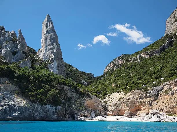
The main cliff rises approximately 400 meters above the sea. The rocky needle — the "aguglia" — stands at 143 meters and is an internationally renowned climbing route. Below, a beach of white shingles borders remarkably clear turquoise water. Dense Mediterranean vegetation (maquis, junipers, mastic trees) covers the slopes down to the cliff edge.
History and Context
The site belongs to the Baunei area, a municipality in Ogliastra renowned for its limestone cliffs of the coastal Supramonte. Punta Goloritzé was declared a natural monument by the Sardaigne region in 1993, putting an end to intensive tourism development projects planned in the 1980s. Management of visitor flow has since been entrusted to the municipality and approved guides.
Highlights of Your Visit
The Trail from the Golgo Plateau
The starting point is from the Golgo plateau, at approximately 900 meters altitude. The trail descends through maquis and limestone rocks down to the beach. The descent is steep in places; the return requires real physical effort. Views of the Gulf of Orosei open up progressively as you approach the cliff edge.
The Beach and Swimming
Goloritzé beach is composed of white shingles and rocky blocks. The water is shallow near the shore and remarkably clear. Swimming is possible, but the lack of services (no bars, no infrastructure) means you must bring water and food.
The Rocky Needle
The aguglia attracts climbers from around the world. The climbing routes are reserved for experienced practitioners. Even without climbing, observing the rock face from the beach gives you a precise sense of the site's scale.
The Boat Excursion
Boats departing from Santa Maria Navarrese or Arbatax skirt the cliffs of the Gulf of Orosei before landing at Goloritzé. This approach from the sea offers a perspective of the entire limestone coastline impossible to obtain from the trail.
Photography Tips
Morning light illuminates the cliff frontally from the beach. In late afternoon, the needle falls into shadow but the sea takes on warmer hues. To photograph the entire cliff-needle-beach ensemble, retreat to the rocks at the far end of the beach. From the boat, late-day backlighting accentuates the relief of the rock faces.
Location and Access
Punta Goloritzé is located on the east coast of Sardaigne, in the Ogliastra province. The most common land departure point is the Golgo plateau, accessible by car from Baunei. Santa Maria Navarrese, a few kilometers to the south, is the main hub for boat excursions. Wheelchair accessibility is impossible: the trail is steep and unmaintained, and the beach is only accessible on foot or by boat.
Nearby places accessible from the same area:
- Cala Luna — another emblematic beach in the Gulf of Orosei, accessible by boat or on foot.
- Cala Mariolu — shingle beach renowned for its clear water, in the same cliff sector.
- Santa Maria Navarrese — coastal village with a port, departure point for boats to the Gulf of Orosei.
- Gorropu Gorges — limestone canyon in the interior Supramonte, accessible from Dorgali or Urzulei.
Nearby
- Cala Luna — crescent-shaped beach bordered by caves, accessible only by sea or by a long trail from Cala Gonone.
- Cala Mariolu — white shingles and turquoise water, often combined with Goloritzé on boat excursions.
- Bue Marino Cave — sea cave near Cala Gonone, formerly inhabited by monk seals.
- Santa Maria Navarrese — village with a 15th-century Aragonese tower and a classified thousand-year-old olive tree.
Frequently asked questions
Yes. Access to the protected zone is regulated and a daily permit is mandatory. It can be obtained from Baunei municipality or through approved hiking agencies on site.
Spring (May-June) and early autumn (September-October) offer pleasant temperatures for hiking and fewer crowds than July-August. In mid-summer, the daily visitor quota is often reached early in the morning.
Both approaches are complementary. The trail from Golgo provides access to the cliffs and beach with an immersion in the maquis. The boat allows you to see the entire limestone coastline and arrive directly at the beach without significant physical effort.
The trail is classified as moderately difficult. The descent to the beach is steep and the return requires a good level of fitness. Hiking boots with cleated soles are essential; sandals are not recommended.
None. No bars, restaurants, or drinking water available. Bring sufficient water and food for your entire visit.
Yes, by boat. Excursions departing from Santa Maria Navarrese or Cala Gonone often include multiple stops: Goloritzé, Cala Mariolu, and Cala Luna on the same day.
Interested in this visit?
We can include it in your personalised itinerary.